The fort is situated on the western slopes of Mount Brandon, six miles north of Dingle. It has commanding views of the surrounding countryside and the coastline, overlooking to the North, Cuas, the harbour traditionally associated with St. Brendan.
The mouth of Smerwick Harbour can be seen to the south and also the island of Tiaracht, one of the Blasket Islands, on the southern horizon. It is one of very few forts in the area which has a line of sight to both of these harbours. Defence was an obvious consideration in its construction.
Ringforts are constructed of stone or a combination of earth and stone. (A fine earthen fort with stone facing and collapsed clochauns (stone houses) is located in the next field).
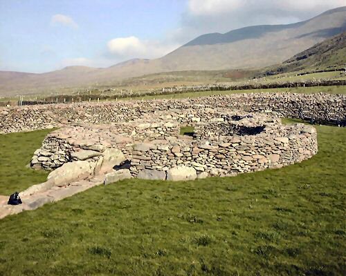
Cathair Fionnurach is a cashel or stone fort and was the homestead of a wealthy farmer of the early medieval period. The fort was probably built between the 8th and the 10th century A.D. Such defended homesteads were necessary in the Ireland of that time because conflict over land and cattle was a common aspect of society.
The local name for the fort is Cathair a Bhoghasin, meaning the ‘Fort of the Rings’ or the ‘Fort of the Rainbow’. The fort contains a number of interesting features which were uncovered during excavations of the site from 1994-1997. Much new information was obtained about early settlement in the region as a result of this research project.
The fort and the structures within it are of drystone construction. There is a circular wall enclosing a large two-roomed house and an underground chamber known as a souterrain. A shallow internal ditch skirts the wall of the fort. The souterrain is located underneath the house and is accessed by a passage located in the smaller room. The fort is 29m in diameter and the enclosing wall survives to a height of 2.5m and is up to 3.5m in thickness.
THE HOUSE
The two rooms of the house are conjoined in a figure of eight shape and are linked by stone steps. The rooms are circular internally and measure 6.5m and 4.5m respectively.
The larger room is centrally placed within the fort and is accessed via a paved pathway leading from the fort entrance at west. An internal drain and associated sump, which is paved over, is also located within the large room. A series of postholes within each of the rooms indicates the former presence of timbers to hold a thatched roof in position and also suggests the former presence of internal divisions within the house.
Some postholes may have resulted from internal wooden fixtures and fittings such as stools and benches which no longer survive. The larger room contained two hearths or fireplaces, an iron smelting furnace, a pit containing pig bone and a large stone-lined pit. The smaller room also contained a hearth.
The most interesting evidence of internal division within the house was the finding of a double line of postholes around the entrance to the souterrain in the smaller room. These postholes would have held a wattled fence to prevent the occupants of the room from falling into the souterrain opening. The smaller room is accessed via a southern entrance as well as being accessed from the larger room.
THE SOUTERRAIN
The word ‘Souterrain’ comes from the French ‘sous terrain’ meaning ‘underground’. Souterrains were used for refuge and storage and a variety of techniques were used to build them. They were either stone built, rack cut, or earthen cut. The Ballynavenooragh example is stone built and it is more likely to have been used for storage because there is no attempt to conceal the entrance. It is entered via a stone-lined pit which is partly arched over by the inner wall face of the smaller house at east. The chamber is reached via an earthen ramp and stone steps which descend from the pit to meet the chamber at right angles. It is slightly curved and is roofed with large stone slabs.
Excavation of the souterrain revealed a number of shallow pits cut into the original floor. A shallow gully and a sump were also uncovered. It appears that rising water was a problem and, in an effort to deal with this, a layer of stones was laid down to create a new floor at a higher level.
WALL FEATURES
The cashel wall originally contained two chambers. One of these was removed when the construction of a farm trackway damaged a portion of the wall in the south and south east. The second chamber was rediscovered during the course of excavation. It has a low, linteled doorway with a step down into a paved entrance. The interior is relatively spacious and can hold up to 20 people. The entrance to these chambers would have been easy to conceal and they may have been used for refuge in times of danger. They may also have been used for storage.
The wall had been interfered with in the south east through to the west quadrant. Along the southern circumference it was removed to facilitate a farm trackway. This damage has been repaired as part of conservation works. The entrance to the cashel is in the west sector. It is quite narrow, being only 1.4m wide. The southern jamb stone and part of the cashel wall to the south west of the entrance were damaged to foundation level; this area has also since been repaired. The entrance may have been roofed over originally and a large pesthole there suggests the former presence of a wooden door or gate.
A wall niche is present in the internal face of the north west sector of the cashel wall close to the ground level. Early plans of the site show terraces and steps along the internal wall face and a letter of 1893 describes the site as follows:
‘…the wall which surrounds the caher is 11 feet thick and was ascended on the interior by steps and benches…’ These were uncovered during the course of excavation and have since been restored.
LARGE PIT
A 2m wide, 1.9m deep pit was excavated within the fort. It is situated close to the external northern wall face of the larger room of the house. It is partly stone lined, using a large natural boulder, and some deliberately-laid stones. The hole had been deliberately backfilled. When the upper stone fill was removed several layers of organic material were identified. These contained straw, grasses, flax and various fruit species such as apple and blackberry. Hazelnuts and grape seeds were also found. The presence of faeces indicates that it was used as a cess pit.
EXTERNAL SETTLEMENT
An irregular field wall abuts the fort in the western sector. This was investigated through survey and trial excavation. This resulted in the identification of the remains of three clochauns which had been partly removed to construct the boundary. It is difficult to date these sites because the building of clochauns survived in the area until recent times. The irregular field boundary is indicated on the 1st edition of the Ordnance Survey. This suggests that these clochauns pre-date the mid 19th century. They may even be associated with medieval occupation of the cashel.
FINDS FROM THE EXCAVATION
Most of the finds from the excavation consisted of simple stone tools such as sharpening stones and strike-a-lights. The only pottery from the site consisted of a few fragments of imported pottery from the eastern Mediterranean, known as B Ware. This type of pottery generally dates to the 6th century A.D., and is possibly associated with an earlier settlement on the site of the cashel. Some of the more interesting finds included two iron knives, a fragment of a miniature iron saw, fragments of a blue glass bead, and fragments of a crucible, used for pouring molten metal. The presence of an iron smelting furnace on site combined with the presence of iron slag and a crucible indicates that the occupants were manufacturing their own metal on site. Two Henry III pennies of mid 13th century date and a lead weight were also found. A lathe-turned lid with a mirror inset and a lathe-turned platter were found in the large pit. The pit contents appear to be post-Norman in date. This site may have been in use as early as the 6th century. The present fort was built subsequently and was occupied, at least intermittently, until the 13th century. it would not have been possible for us to complete this project were it not for the support of:
- Comharchumann Forbartha Chorca Dhuibhne
- The Dunfey Family
- The Ireland Funds
- Clár Leader-Meitheal Forbartha na Gaeltachta Teo
- Comharchumann Forbartha Chorca Dhuibhne
- Dúchas The Heritage Service
- The Heritage Council
Photographs are courtesy of Dúchas The Heritage Service, The National Museum of Ireland and Graftronaic. Text by Erin Gibbons, Site Director.